Stationsweg 7, 3143 LS Maassluis
Situato in Stationsweg a Maassluis, questo immobile postbellico fu costruito nel 1960. La superficie abitabile e di 307 m². L'indirizzo si trova nel quartiere Taanschuurpolder, comune di Maassluis, provincia di Zuid-Holland. L'etichetta energetica e D. C'e potenziale di risparmio energetico attraverso miglioramenti sostenibili.
Valore e costi
📌 Key address facts
The key facts available directly from BAG, CBS and address-level data. Heavier charts and maps load after this summary.
Neighborhood and street
This address is in Taanschuurpolder. The neighborhood has about 2.915 residents. The same postcode contains 15 other addresses in this comparison.
Median area in this postcode: 18 m².Median build year: 2000.
Nearby amenities
No reliable amenities summary is available in the initial HTML yet.
Address profile
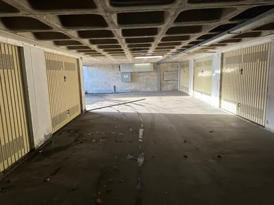
Stationsweg 7 in Maassluis is a industrial, retail with 307 m2 living area, built in 1960, postcode median 18 m2. The build period is classified as post-war building, which helps assess maintenance, energy performance and comparable homes.
The location combines Taanschuurpolder neighborhood, very urban neighborhood. Use the street, neighborhood and city links to compare this address with nearby homes.
As an initial value signal, we show neighborhood WOZ around EUR 326.000, life score 38/100 (limited), energy label D. For a buying or selling decision, recent transactions, property condition and legal restrictions remain important.
📈 Dati chiave
🌟 Punteggio di vita
Componenti del punteggio
Pochi dati locali per questa posizione; i fattori stimati derivano dalla densità di popolazione.
🏠 Punteggi di posizione
ⓘ Come calcoliamo questi punteggi?
Each score ranges from 0 to 100. Higher is better. The rating scale is:
Fonti: CBS, BGT, PDOK, BAG. I punteggi sono calcolati automaticamente e sono indicativi.
📈 Cronologia valore WOZ (10 anni)
Monitora le variazioni annuali del valore WOZ per questo indirizzo, incluso l'aumento o il calo anno su anno.
Caricamento cronologia WOZ...
Caricamento trend WOZ del comune...
📈 Storico vendite
Initial value signal
The average WOZ value in this neighborhood is EUR 326.000.
Active asking price: EUR 45.000
The interactive price history is enriched here when detailed data is available.
💵 Vendite comparabili nelle vicinanze
View recently sold nearby properties with similar characteristics for extra market context.
Loading comparable sales...
🎯 Consulente offerta
L'edificio
🏦 Confronta i tassi del mutuo
📍 Dettagli indirizzo
| Via | Stationsweg |
| Numero civico | 7 |
| Postcode | 3143 LS |
| Città | Maassluis |
| Comune | Maassluis |
| Provincia | Zuid-Holland |
| Quartiere | Taanschuurpolder |
| Distretto | Wijk 01 Taanschuurpolder |
| Funzione | Industrial, Retail |
| Anno di costruzione | 1960 |
| Superficie | 307 m² |
| BAG ID | 556010000014303 |
🏗 Edificio e caratteristiche
| Anno di costruzione | 1960 |
| Superficie abitabile | 307 m² |
| Tipo | Industrial, Retail |
| Stile architettonico | 1960s/70s construction style |
| Status | In uso |
🏢 3D Building Profile
🛠 Piano di manutenzione
Based on construction year (1960) and age (66 years), an indicative maintenance plan has been prepared.
This property is 66 years old. A structural survey is advisable. Check: foundations, roof, pointing and plumbing.
▶ Vedi piano di manutenzione completo
Controlli e manutenzione di routine per ogni abitazione.
- Testa tutti i rilevatori con il pulsante test
- Sostituire la batteria: annualmente
- Sostituire completamente dopo 10 anni
- Premi il pulsante test
- L'interruttore deve scattare
- Nessuna risposta: chiama un elettricista
- Pulisci le griglie di ventilazione
- Controlla i filtri
- Sufficiente circolazione d'aria
- Manutenzione annuale dell'installatore
- Sfiata i termosifoni
- Pressione acqua 1-1,5 bar
- Pulisci grondaie, rimuovi foglie
- Controlla gli scarichi
- Ispeziona ruggine/perdite
- Controlla sigillanti bagno/cucina
- Sostituisci sigillanti staccati
- Controlla le fughe del muro esterno
Estimated costs and intervals based on construction year 1960 and floor area.
⚡ Energia e sostenibilità
Estimated from build year and area.
Check insulation, glazing and heating for upgrade potential.
Upgrade opportunities
Check insulation, glazing and heating for upgrade potential.
- Start with measures that fit build year 1960.
- Use the 307 m² area for realistic payback estimates.
- Electricity usage: 15315 kWh.
- Gas usage: 3991 m³.
Solar and savings
This address has coordinates and floor area available. After loading, the solar card can show a roof and savings estimate.
🛠 Rischio fondazioni (RVO)
Caricamento dati delle fondamenta...
📄 Proprietà e Catasto
Caricamento dati della particella...
Caricamento restrizioni...
Fonte: PDOK / Kadaster BRK & BRK-PB
⚠️ Rischio amianto
🏛 Monumenti nazionali
🏛 Pianificazione e permessi
Caricamento contesto di pianificazione...
🏠 Profilo del quartiere (CBS)
Caricamento dati del quartiere...
🏢 Punteggio del quartiere
🛡 Sicurezza e criminalità
🩹 Profilo sanitario
🎓 Scuole nelle vicinanze
🏫 Asili nelle vicinanze
📍 Amenities
Distances are straight-line. Source: OpenStreetMap + Google Maps
🚗 Permesso di parcheggio
🏭 In evidenza nei dintorni
🏠 Vista 3D del quartiere
🌍 Climate Check
🌊 Rischio di inondazione
⬇️ Subsidenza
🔊 Livello di rumore
🍃 Qualità dell'aria
🚹 Sicurezza stradale
Nessun dato sul traffico per questo quartiere.
🌀 Turbine eoliche nelle vicinanze
🌳 Natura protetta
Caricamento natura protetta...
🌞 Posizione del sole
Il quartiere
♨ Teleriscaldamento
📡 Connettività
🌿 Aree verdi nelle vicinanze
Ambiente e rischi
🌎 Ambiente fisico (BGT)
Caricamento dati ambientali...
📍 Visualizza questo indirizzo
🏛 Indirizzi nelle vicinanze
-
132 m²3143 DD Maassluis
-
178 m²3143 DC Maassluis
-
122 m²3143 DA Maassluis
-
117 m²3143 DA Maassluis
-
127 m²3143 DD Maassluis
-
162 m²3143 DA Maassluis
-
185 m²3143 DC Maassluis
-
155 m²3143 DA Maassluis
📈 Comparable addresses (3143 LS)
| Address | Area | Built |
|---|---|---|
| Stationsweg 15 | 18 m² | 2000 |
| Stationsweg 16 | 18 m² | 2000 |
| Stationsweg 17 | 18 m² | 2000 |
| Stationsweg 18 | 18 m² | 2000 |
| Stationsweg 19 | 18 m² | 2000 |
| Stationsweg 20 | 18 m² | 2000 |
| Stationsweg 21 | 18 m² | 2000 |
| Stationsweg 22 | 18 m² | 2000 |
| Stationsweg 23 | 18 m² | 2000 |
| Stationsweg 24 | 18 m² | 2000 |
| Stationsweg 25 | 18 m² | 2000 |
| Stationsweg 26 | 18 m² | 2000 |
| Stationsweg 27 | 18 m² | 2000 |
| Stationsweg 28 | 18 m² | 2000 |
| Stationsweg 29 | 18 m² | 2000 |
📚 Registro e Catasto
| BAG Nummeraanduiding ID | 556010000014303 |
| Comune | Maassluis |
| Coördinaten (WGS84) | 51.91675° N, 4.25373° E |
Checklist di due diligence
| Document | Scopo | Dove ottenere |
|---|---|---|
| Estratto catastale | Cronologia di proprietà | kadaster.nl |
| Contratto di enfiteusi | Termini di locazione | Venditore/notaio |
| Documenti VvE | Bilancio, MJOP, verbali | Venditore/amministratore VvE |
| Certificato energetico | Official label validation | Venditore/perito |
| Piano regolatore | Piano regolatore comunale | maassluis.nl |
🏡 Neighborhood information in Maassluis
Fonte: CBS Wijken en Buurten (2024). Vedi pagina del quartiere →
💸 Stai pagando un affitto? Verifica se paghi troppo — e recupera i tuoi soldi.
Estimate in 2 minutes whether your rent is too high, based on the WWS points system and current regulations.
✨ Lo sapevi che...?
✅ Checklist visita
Legale e tecnico
❓ Domande frequenti
What is the postcode for Stationsweg 7?
De postcode van Stationsweg 7, Maassluis is 3143 LS. Dit adres ligt in de wijk Taanschuurpolder, gemeente Maassluis, provincie Zuid-Holland. Nederlandse postcodes bestaan uit vier cijfers gevolgd door twee letters. De eerste twee cijfers geven de regio aan, de laatste twee cijfers samen met de letters geven een specifieke straat of deel van een straat aan. De postcode 3143 valt binnen het postcodegebied van Maassluis. In dit postcodegebied vindt u meerdere adressen met vergelijkbare kenmerken qua bouwjaar en woningtype. Het postcodesysteem wordt beheerd door PostNL en is essentieel voor postbezorging, navigatie en officiële registraties bij de overheid. Op WoningSearch kunt u alle adressen binnen hetzelfde postcodegebied bekijken en vergelijken op basis van oppervlakte, bouwjaar en WOZ-waarde. The postcode for Stationsweg 7, Maassluis is 3143 LS. This address is located in the Taanschuurpolder neighborhood, municipality of Maassluis, Zuid-Holland province. Dutch postcodes consist of four digits followed by two letters. The first two digits indicate the region, while the remaining digits and letters narrow it down to a specific street or section of a street. The postcode 3143 falls within the Maassluis postal area. Within this postal area you will find multiple addresses with similar characteristics in terms of construction year and housing type. The postcode system is managed by PostNL and is essential for mail delivery, navigation, and official government registrations. On WoningSearch you can view all addresses within the same postcode area and compare them based on living area, construction year, and WOZ value.
When was Stationsweg 7 built?
Stationsweg 7 in Maassluis is gebouwd in 1960. Het heeft een woonoppervlakte van 307 m². Dit bouwjaar is geregistreerd in de BAG (Basisregistratie Adressen en Gebouwen), de officiële overheidsdatabase die door het Kadaster wordt beheerd. Het bouwjaar geeft aan wanneer het pand oorspronkelijk is opgeleverd. Woningen uit deze periode zijn vaak gebouwd tijdens de naoorlogse woningnood en kenmerken zich door functioneel ontwerp. Let op het energielabel, want isolatie kan beperkt zijn. Op WoningSearch kunt u het bouwjaar vergelijken met andere woningen in de Taanschuurpolder. Stationsweg 7 in Maassluis was built in 1960. It has a living area of 307 m². This construction year is registered in the BAG (Basisregistratie Adressen en Gebouwen), the official government database managed by the Kadaster. The construction year indicates when the building was originally completed. Homes from this period were often built during the post-war housing shortage and feature functional design. Pay attention to the energy label, as insulation may be limited. On WoningSearch you can compare the construction year with other properties in the Taanschuurpolder.
What neighborhood is Stationsweg 7 in?
Stationsweg 7 ligt in de wijk Taanschuurpolder (stadsdeel Wijk 01 Taanschuurpolder), Maassluis, gemeente Maassluis. De buurtindeling is gebaseerd op de CBS Wijken en Buurten classificatie, die door het Centraal Bureau voor de Statistiek wordt bijgehouden. Elke buurt in Nederland heeft een unieke code die wordt gebruikt voor statistische analyses. Voor de buurt Taanschuurpolder zijn op WoningSearch gedetailleerde statistieken beschikbaar, waaronder gemiddelde woningwaarde, bouwjaarverspreiding, energielabelverdeling, demografische gegevens en veiligheidsscores. Deze gegevens komen uit officiële overheidsbronnen zoals CBS, BAG en het Kadaster. Bekijk de volledige buurtpagina van Taanschuurpolder voor alle statistieken en een overzicht van alle adressen in deze buurt. Stationsweg 7 is located in the Taanschuurpolder neighborhood (Wijk 01 Taanschuurpolder district), Maassluis, municipality of Maassluis. The neighborhood classification is based on the CBS Wijken en Buurten system maintained by Statistics Netherlands (CBS). Every neighborhood in the Netherlands has a unique code used for statistical analysis. For the Taanschuurpolder neighborhood, WoningSearch provides detailed statistics including average property value, construction year distribution, energy label breakdown, demographic data, and safety scores. This data comes from official government sources such as CBS, BAG, and the Kadaster. Visit the full Taanschuurpolder neighborhood page for all statistics and a list of every address in this area.
How large is Stationsweg 7?
Stationsweg 7 in Maassluis heeft een woonoppervlakte van 307 m² volgens de BAG (Basisregistratie Adressen en Gebouwen). De woonoppervlakte wordt gemeten volgens de NEN 2580 norm en omvat alle verblijfsruimten van de woning, exclusief berging, garage en buitenruimten. In de buurt Taanschuurpolder kunt u de oppervlakte vergelijken met andere woningen om te zien of deze woning groter of kleiner is dan gemiddeld. De oppervlaktegegevens worden wekelijks bijgewerkt vanuit het Kadaster. Stationsweg 7 in Maassluis has a living area of 307 m² according to the BAG (Basic Registry of Addresses and Buildings). The living area is measured according to the NEN 2580 standard and includes all habitable rooms, excluding storage, garage, and outdoor spaces. In the Taanschuurpolder neighborhood you can compare the area with other properties to see if this home is larger or smaller than average. Area data is updated weekly from the Kadaster.
What type of property is Stationsweg 7?
Stationsweg 7 in Maassluis is geregistreerd als industriefunctie,winkelfunctie in de BAG. Dit pand heeft de gebruiksfunctie industriefunctie,winkelfunctie. De oppervlakte bedraagt 307 m². Het is gebouwd in 1960. Het gebouwtype wordt vastgesteld door de gemeente en geregistreerd in de Basisregistratie Adressen en Gebouwen. Stationsweg 7 in Maassluis is registered as Industrial, Retail in the BAG. This building has the function Industrial, Retail. The area is 307 m². It was built in 1960. The building type is determined by the municipality and registered in the Basic Registry of Addresses and Buildings.
What is the WOZ value of Stationsweg 7?
De WOZ-waarde (Waardering Onroerende Zaken) van Stationsweg 7 in Maassluis wordt jaarlijks vastgesteld door de gemeente Maassluis. De WOZ-waarde is gebaseerd op de geschatte marktwaarde per 1 januari van het voorgaande jaar en wordt gebruikt voor de berekening van onroerendezaakbelasting (OZB), waterschapsbelasting en het eigenwoningforfait. Dit pand is gebouwd in 1960. De woonoppervlakte is 307 m². Op WoningSearch vindt u de WOZ-waardehistorie inclusief waardetrends in de buurt Taanschuurpolder. De WOZ-waardegegevens komen van het Kadaster Waardeloket en CBS. The WOZ value (Waardering Onroerende Zaken) of Stationsweg 7 in Maassluis is determined annually by the municipality of Maassluis. The WOZ value is based on the estimated market value as of January 1st of the previous year and is used to calculate property tax (OZB), water authority tax, and the deemed rental value for income tax. This property was built in 1960. The living area is 307 m². On WoningSearch you can view the WOZ value history including value trends in the Taanschuurpolder area. WOZ data comes from the Kadaster Waardeloket and CBS.
What daily amenities are available at Stationsweg 7?
In de directe omgeving van Stationsweg 7 in Maassluis vindt u diverse dagelijkse voorzieningen. Op basis van OpenStreetMap data toont WoningSearch de dichtstbijzijnde supermarkten, huisartsen, apotheken, scholen, kinderopvang, restaurants, parken en OV-haltes met exacte afstanden. De buurt Taanschuurpolder is een ruime woonwijk in Maassluis, gemeente Maassluis. Bekijk de sectie 'Voorzieningen in de buurt' op deze pagina voor een compleet overzicht van alle nabijgelegen faciliteiten inclusief afstanden in meters. De voorzieningen worden regelmatig bijgewerkt op basis van de nieuwste OpenStreetMap data. In the immediate vicinity of Stationsweg 7 in Maassluis, you will find various daily amenities. Based on OpenStreetMap data, WoningSearch displays the nearest supermarkets, GPs, pharmacies, schools, daycare centers, restaurants, parks, and public transport stops with exact distances. The Taanschuurpolder neighborhood is a spacious residential area in Maassluis, municipality of Maassluis. Check the 'Nearby Amenities' section on this page for a complete overview of all nearby facilities including distances in meters. Amenities are regularly updated based on the latest OpenStreetMap data.
📄 Scarica il rapporto di proprietà
Download a complete PDF report of this property with all data including WOZ history, neighborhood statistics, features, and planning context
Richiedi una valutazione gratuita per questo indirizzo
A local agent will contact you within 24 hours — no obligations.
⚖️ Confronta questo indirizzo
Save this property to your comparison tray, then browse local realtors when you are ready to make an offer.
- Plot
- 1045 m²
- Listed since
- Vandaag
- Tipo
- Parking
- Handover
- In overleg
Photos 7


Similar listings
📞 Richiedi una valutazione gratuita
Request a free valuation for this address. A local agent will contact you within 24 hours — no obligations.